|
Four
sections make up the town of Redding, Connecticut: Georgetown,
Redding Center, Redding Ridge and West Redding. I receive
quite a few e-mails about Redding and most request an insiders
guide to Redding, Connecticut. Having grown up here and having
the insight of five generations in Redding I do know what
it was and what it has become.
Georgetown:
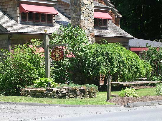
Georgetown
has a very rich history and the Gilbert and Bennett Wire Manufacturing
Company played a key role in the town's development. After
a down period of about 20 years, Georgetown is coming around
again. The town has a bright future, and at the present time
housing purchases should provide buyers with a positive return
in the coming years. The
Gilbert & Bennett Wire Mill Renovation Project is
underway and will tranform this industrial district of Redding
into a major hub of business, residential, and recreational
activity.
It's
location is advantageous to commuters who work in the Southern
Fairfield County area and New York City (Branchville Train
Station). Route 7 is the main route to southern Fairfield
County towns but on most days it is quite congested. Georgetowners
"in-the-know" opt for a backroad route into Weston
via Route 57, then down to Route 53 into Wilton where they
can re-connect with Route 7 via Route 33, or continue on Route
53 to Norwalk where they can hop on I-95.
Georgetown
is Redding's "hot-spot" in terms of nightlife. The
Georgetown Saloon has been entertaining customers with it's
Country-Western style since 1978. The Saloon has a winning
combo of great food and entertainment. In addition, Rancho
Alegro Mexican Restaurant, Lombardi's Pizza, and a new Seafood
Restaurant make Georgetown's Main Street the place to be when
the sun goes down. Golden Village and East Cafe are close
by and offer Chinese and South Asian menu options.
As
noted, Georgetown's borders extend into Redding, Weston and
Wilton so if you are interested in viewing Georgetown listings
make sure you specify your needs to the Realtor. Online searches
for properties in Georgetown will result in 0 listings in
most cases, because they get looped in with Redding, Weston,
Wilton listings in real estate databases.
Redding
Center:
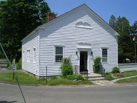
Redding
Center today is much like it was when the town received Parish
status in 1729, the center of town business affairs. The scenery
has certainly changed but the Center is still where all town
business takes place in the Town Hall building and at the
Old Town House.
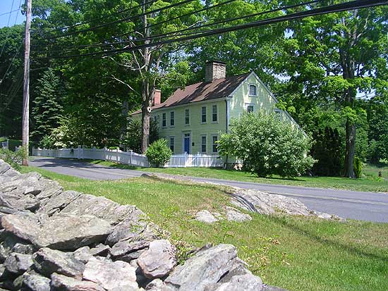
Redding
Center is also where you'll find a good number of Historic
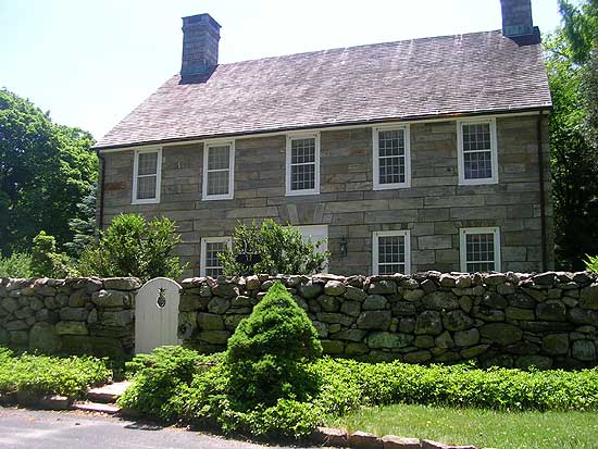
Homes. One of my favorite properties is currently for sale,
it dates to 1753 and has a very interesting past (During the
Revolutionary War, munitions were stored in the attic of the
house by the Rev. Bartlett). In 1753, the Rev. Nathaniel Bartlett
and his wife Eunice began construction of the New England
salt-box style house, on 20 acres of land donated by the Congregational
church, being a common practice of the era. Per the Redding
Church Records, the property was deeded over to the Rev. Nathaniel
Bartlett on June 08, 1753, by Deacon Lemuel Sanford. In its
external appearance, it remains virtually unchanged from how
it must originally have looked, except for a wing added on
to the east in 1847, and a patio out back. It is located at
#10 Cross Highway, just off Route # 107 in Redding Center,
directly across from the "Heritage House" -former senior center.
#20 Cross Highway which abuts the Bartlett/Sanford property
is currently for sale as well.
What's
great about Redding Center is that gems like these are preserved
and every once in a while enter the market. A drive along
Cross Highway takes you over the hills and valleys that at
one time marked the northern boundary of Fairfield. Yes, Fairfield
once extended that far. But Redding Center is more than just
Cross Highway. Sanfordtown Road and Lonetown Road are two
sections that I find appealing. Sanfordtown Road leads down
to the Sanfordtown section of Redding which at one time was
a manufacturing district of town. The Sanfordtown section
has a number of new houses and developments along Newtown
Turnpike. Lonetown Road leads you to the location of one of
Redding's earliest settlements: Lonetown Manor, home of John
Read, Jr. and Sr. two very important individuals in town history.
It is also where the Native American tribes that occupied
Redding at the time of its settlement resided. At the corner
of Lonetown and Putnam Park Road (Route 107) a vacant hillside,
once known as "Chickens Hill" offers a look at what
it may have looked like way-back-when.
Redding
Center has been built up over the years but it still mantains
a rural character and it is a very convenient location in
town. Redding Elementary School, the Redding Community Center,
the Town House, Historical Society and Redding Country Club
all are located on Lonetown Road. Putnam Memorial Park is
a short distance north. Redding Center residents have quick
access to the larger town of Bethel, and the business district
of West Redding. Those wishing to enjoy a quiet afternoon
at the Reservoir simply head down Sherman Turnpike or as it
was once called Lover's Lane.
Redding
Ridge:
Redding
Ridge is a historically significant section of Redding. It
was referred to as Chestnut Ridge by early settlers and settlement
here may date as far back as 1709. The book: My Brother Sam
is Dead, which chose Redding Ridge for it's setting has made
it a very popular search term here at the History of Redding.
While the book is historic fiction many of the events described
did occur : The British stopped here on their way burn Danbury,
and the Anglican Church that served as an important element
of the story is here too.
Redding
Ridge has a number of sub-sections: Aspetuck Valley, Southern
Black Rock Turnpike, Center Ridge, Northern Black Rock, Hopewell
Woods/Sunset Hill. Route 58 a.k.a. Black Rock Turnpike is
the main road in this section of town.
Aspetuck
Valley
The
Aspetuck Valley follows Poverty Hollow Road. This area is
one of Redding's quietest residential areas and despite the
name of the road is quite an affluent community. This section
of town was once an industrial district in the 1800's, making
use of the Aspetuck River to power mills and factories. Almost
as quickly as these mills and shops appeared they failed and
faded away leaving the workforce that supported them in poverty.
The Poverty Hollow namesake is believed to have come from
the conditions area inhabitants endured as the community entered
the 1900's.
Around
1905, a forward thinking gentleman named Noble Hoggson with
a passion for architecture and the funds to fuel his passion,
envisioned an upscale community development in the impoverished
Aspectuck district. He renamed the area "Pleasant Valley"
and with many of his influential friends and associates purchased
a good number of properties in the Aspectuck Valley transforming
them into grand estates. His timing was great, Redding became
front page news all over the World when Samuel L. Clemens
(Mark Twain) arrived in 1908. Once relatively unknown, many
artists, writers
and others of wealth and influence became aware of its
rural beauty and flocked here. Many of the impressive estates
on Poverty Hollow Road in the present day are the work or
influence of Mr. Hoggson, of course, the original homesteads
of the Aspectuck Valley were demolished or greatly altered
to achieve Hoggson's visions.
Homes
in the Aspetuck Valley tend to be on the high-end of the market
but it is well worth the price. Residents enjoy the rural
serenity of this area, yet have easy access to Easton, Newtown,
and Monroe, Connecticut. The high school is also a short distance
away which is great for those who enjoy playing tennis, walking
the track, chipping golf balls or catching a ballgame.
New
Trail: Six
mile trail opens on Poverty Hollow Road
Southern
Black Rock
Southern
Black Rock is on the Easton, Connecticut side of town. It's
my own title for the area and I start it at the High School
entrance on Rt. 58 heading south to the Easton/Redding line.
This
area doesn't have many side streets, I can only think of one:
Pine Tree Road. So the houses in this section are close to
Route 58. That may be an undesirable aspect to those with
pets and small children but on the flip-side many of these
properties border open-space (watershed property) which is
nice...just plan on planting deer-resistant flowers and bushes.
Expect
to pay anywhere from $400,000 to $800,000 in this section.
Recent sale: Pine Tree Road, $500,000.
Ridge
Center
This
section starts at the High School entrance heading north and
ends at Sunset Hill.
This
area is where Redding's earliest settlers built their homesteads,
ridges were preferred over valleys and the north-to-south
highways ran through here. Ridge Center was once an educational
paradise for children of the "well-to-do" thru the
visions and efforts of Daniel Sanford. Daniel established
the Redding Institute which later became known as the Sanford
School in 1905. The grounds of the School at the corner of
Church Hill and Black Rock Trpk. were once a large farm owned
by Thomas Ryan...I believe Onions were an important crop for
Mr. Ryan, at least that's what I've been told. In the summer
months the school served as the Ridgewold Inn. Another Inn
known as the Ridge Inn existed in this section too. Today
the Jesse P. Sanford Boys and Girls Club carries on the teaching
tradition via athletics and youth programs.
There
are a good number of house options and price ranges in this
area, plenty of side streets and long driveways to buffer
the traffic on Route 58. The Catholic Church and Episcopal
Church are located here, as is the Redding Ridge Fire Dept.
Northern
Black Rock
This
section begins at the corner of Sunset Hill and Route 58 and
continues north to the Redding/Bethel line.
This
stretch of road once ended at John Read Road, from there you
could take a western route and come out in Lonetown or head
north up Sunset Hill to Bethel, Connecticut. Route 58 changed
all that and in recent years this section of town has added
new homes, roads and developments.
It
is convenient to Bethel and Newtown, Connecticut. The Little
River Valley runs through most of it. There is hiking along
the river off of John Read Road, and on the Bethel side is
Putnam Memorial Park. In addition to it's educational appeal,
Putnam Park is a fun place to picnic and fish in the summer
months.
Expect
to pay anywhere from $400,000 to $1,300,000 in this section.
Hopewell
Woods/Sunset Hill
New
homes and developments have been on the rise in this area
for the last 25 years. Hopewell Woods is the cross route to
Newtown via it's connection to Poverty Hollow, Sunset Hill
is the back route to Bethel. Both these roads have a long
history in Redding, Sunset Hill's more glamerous than Hopewell's.
Sunset
Hill was the main turnpike route from Redding to Bethel and
was the route to Danbury taken by British troops in 1777.
Formerly known as Couch's Hill and Wiantenuck, many wealthy
individuals have called Sunset Hill home, the most well regarded
being the Huntington's, Anna and Archer, for their 800 acre
"gift" to Redding residents: Huntington State Park.
Most do not know a man named Commodore Walther Luttgen was
responsible for converting this beautiful ridge property into
a sylvan paradise, with lakes and miles of Victorian carriage
drives that now serve as hiking/biking trails. Large farms
and estates have always graced the hilltops of this section,
now-a-days there are just more of them. Homes here are at
the high-end of the market but there are affordable options
available on the side roads.
Hopewell
Woods, wasn't too well thought of by early residents of Redding
Ridge. An example comes from the Ridge's most infamous character,
William Heron, a double agent in the Revolutionary War: "At
one of the annual town meetings, Mr. Hezekiah Morgan, a somewhat
illiterate man, was nominated for grand juror. Squire Heron,
in laced waistcoat, ruffles, and velvet breeches, and aiding
himself with his gold-headed cane, arose to oppose the motion.
"Mr.
Moderator," said he, "who is this Hezekiah Morgan? Why, a
man brought up in Hopewell woods: he fears neither
God, man, nor the devil. "
No
one looks down on the residents of Hopewell Woods these days
as it has grown to contain many fine estates. Most of these
houses are recent additions, coming after the town dump closed
and the recycling center opened. The stretch of road from
the recycling center to Poverty Hollow has been paved and
is much more enjoyable than it once was.
West
Redding
West
Redding has always been an attractive section of town. It
contains quite a few of Redding's finest open space properties,
New Pond Farm and the town park at Topstone.
Gallows
Hill Road, Lonetown Road, Marchant Road, Seventy Acres, Topstone
Road and Umpawaug Road are locations of some of Redding's
finest homes and developments.
A
review of famous people that have called West Redding home,
gives you and idea of why it's considered a prestigious section
of Redding:
- Leonard Bernstein
(50's - Musician, composer...lived on Fox Run Road)
- Katherine
Drier (She was a key player in founding the Museum of
Modern Art in New York City...lived on Marchant Rd in 1912)
- Robert S.
Fitzgerald (Fitzgerald is widely known as one of the
most poetic translators into the English language, best
known as a translator of ancient Greek and Latin. ....lived
on Seventy Acres Road)
- Daryl Hall
(Musician-Hall & Oates. Lived on Topstone Rd.)
- Charles
Ives (Musician...Lived on Umpawaug Hill)
- Joseph Wood
Krutch (40s. Author and Naturalist...lived on Limekiln
Rd)
- Carmen Mathews
(Actress. Lived on Umpawaug/Marchant...New
Pond Farm)
- Albert Bigelow
Paine (Writer. Lived on Diamond Hill)
- Edward
Steichen (Artist-Photographer) Lived on Topstone...actually
Topstone Park was his property)
- Mary Travers
(Musician-Peter, Paul, Mary. Lives on Limekiln Rd.)
- Mark
Twain (Writer) Mark Twain Lane
- Walter White
(40s to 50s, Head of NAACP...lived on Seventy Acres Rd)
For
those interested in American History, West Redding played
a role in that too: Umpawaug Hill served as the headquaters
of General Israel Putnam while his division of Continental
Troops encamped at Redding during the winter of 1778-79. A
Guardhouse, where a spy and a deserter were held prior to
their executions, was also located on Umpawaug Hill.
The
naturalist will be pleased to know West Redding contains:
Saugatuck Falls Natural Area (312 acres), New
Pond Farm (102 acres), Limekiln Natural Area (184 acres),
Reeve Biggers Trail (139 acres), Stormfield (161 acres) and
Topstone Park (274 acres). And that is just to name a few
of them!
The
coming of the Railroad, built between 1850-1852 from Norwalk
to Danbury sparked the business district of West Redding.
While small it is very convenient and contains a hair stylist,
general store, pizza shop, barber, dentist, post office and
a restaurant.
West
Redding is close just about everything in town: Mark
Twain Public Library is 5 minutes away. Both the Elementary
and Middle
School are 5-10 minutes from here. Town
Hall, the Community Center/Senior Center, Country
Club and Historical Society are all short 5-10 minute
drives. If you commute to the city, you can use the West Redding
Train Station.
Amenities outside
of West Redding are also in close proximity: Bethel Center
is 3 miles away, Danbury is 5 miles away, Danbury Fair Mall
is 2.5 miles away, Georgetown is 1.5 miles away, Ridgefield
is 3 miles away, Weston is 3 miles away, Westport is 5 miles
away.
West Redding has
properties for every budget.
Relocating
to Redding, CT? View the Redding
Connecticut Relocation Guide
Ten
Reasons why Redding, CT is an ideal community
Redding,
CT Real Estate Agents Spotlight: William
Pitt Real Estate- Agent
Ginny Beasley
470 Main
Street
Ridgefield, CT 06877
Agent Phn:
203-482-4938
Ginny
Beasley
Ten Reasons
why Redding is The Ideal Choice:�
- Location
- Convenience/Proximity
- State of the
Art Services
- A Healthy Environment
- Comfortable
and Safe
- Sense of Community
- Recreation for
All Tastes
- First Class
Entertainment
- Value for Your
Investment
- A Positive Future
1. Location:
Perfectly Situated Between Big City and Country Relaxation.
- General location
- Near NYC (55
miles)
-
Fairfield
County (Bethel, Danbury, Easton, Fairfield, Newtown,
Ridgefield, Wilton)
- Transportation
- Airports
(LGA, Westchester, Hartford)
- Train (Metro
North, Amtrak)
- Highways
(I-95, Merritt Parkway, I-84)
2.
Convenience/Proximity: Easy Access to All the Basics.
- Nearby (all
the niceties)
- In-town (all
the necessities)
- Georgetown
- Redding
Ridge
- West Redding
walk-to
- HART Bus
- Veterinary
/ Boarding / Kennels
3. State of
the Art Services: Superior Town-wide
Services. Everything you need delivered in an approachable,
friendly, accessible manner.
- EMS/Fire/Police
- Town Hall
- (4) Post Offices
- Community Center
- Heritage House
- Social Services
- Park and Recreation
- Exceptional
Schools
- Volunteer organizations
4. A Healthy
Environment: A Breath of Fresh Air.
-
Simple and
uncongested
-
Clean air,
plentiful water, green open space
- Stay in shape
- Close to Danbury
Hospital
- (Norwalk
and Yale New Haven Hospitals near by)
5. Comfortable
and Safe: Privacy without Isolation.
- Scenic
- Quiet
- Plentiful forest
and open space�(preserved open space + undeveloped land
= 35% of acreage)
- Historic
- Friendly, easy
pace
- Secure, low
crime rate
6. Sense of
Community:
- Active, involved
town spirit
- Preservation
oriented
- Uniqueness is
a trademark
- Motivated and
involved people
- Diverse in population,
housing, religion
- Accessible town
officials and employees
7. Recreation
for All Tastes:
- Hiking,
Picnicking, Boating, Fishing
- Topstone Town
Park
- Audubon Property
- Putnam Historic
State Park
- Huntington
Estate State Park
- Devils Den
Nature Preserve
-
Candlewood
Lake
-
New
Pond Farm�(working farm and park)
- Town
Park and Recreation
- Tennis
Courts (RCC and Joel Barlow HS)
- Multipurpose
Playing Fields
- Playgrounds,
Gymnasiums
-
Classes
and Trips
- Fitness and
Exercise
- Special Events
- Mark
Twain Library
-
Heritage House
Senior Center
- Organizations
8. First Class
Entertainment: Premiere Entertainment without the Fuss.
- Arts
- Redding is
graced with numerous professional artists, musicians,
authors and performers. They regularly contribute their
talents to local organizations providing frequent showings,
readings, seminars and events
- RidgefieldAldrich
Museum & Gallery�
-
Ridgefield
Symphony
- Theater
- A Variety of
Restaurants
- Movies in all
directions
- Bethel Cinema
(3 screenssenior & weekday discounts)
- Danbury Multiplex
-
Ridgefield
Playhouse
- Sports for participation
and viewing
- Year-round
outdoor sports and organized leagues
- Hockey,
Baseball, Basketball (Danbury, Bridgeport, Fairfield
and New Haven semi pro and college teams)
9.
Value for Your Investment: A better investment unavailable
elsewhere in Fairfield County.
- Real Estate
- Unique
- Open
Space...almost 1/3 of Town area
- Gives Seniors
biggest tax breaks in the state
- Consistently
rated #1 in CT for its size
10. A Positive
Future: Future Growth�with a Watchful Eye.
- Georgetown
Re-Development
- Overdevelopment
in Route 7 corridor & surrounding areas (Wilton/Ridgefield)
will make Redding even more unique
- Presence of
Adult Communities (Meadow Ridge and others) fits with town
plans
- Town commitment
to Maintain the positive status quo
Connecticut
Magazine's #1 Small Town!
and has been ranked #1 or #2 for the past decade!!
Relocating
to Redding? View the Redding
Connecticut Relocation Guide
To
be included or upgraded to Site Sponsor, you can e-mail me
at: bcolley@colleyweb.com
or phone me at 860-364-7475. Site Sponsorships are $200 per
month, visit our Ad Space page
for demographics and site stats.
Back
to TOP | Back to Redding
Section | Back to Georgetown
Section
|
|