|
Included
in this Georgetown Early Roadways History section is information
I have gathered from articles by Wilbur F. Thompson. More
information will be added as I find it.
Please
let me know if there are more areas you'd like me to explore
or if you have further information. Contact bcolley@snet.net
or phone me at 860-364-7475.
Georgetown
Early Roadways
For
many years after the first settlement of our state, the roadways
connecting the towns were very poor. Many were mere "bridle
paths," others were Indian Trails widened into "Cart Paths."
One of these was the Indian Trail leading up from the Sound,
at what is now known as Calf Pasture Beach, through the section
now known as Georgetown, into what is now the city of Danbury.
It was over this trail that eight families left Norwalk in
1684, to found the new town of Danbury. And for many years
this trail, widened into a cart path, was the only connecting
link between the two places. When the section now known as
the town of Ridgefield was purchased from the Indians in 1707,
the south and east boundary lines intersected on a rock on
the bank of the Norwalk River. The record states that "Thc
south and east boundary lines meet on the rock on the banks
of the Norwalk River 20 rods north of the Danbury and Norwalk
Cart Path fording place," showing that it was a cart path
at that date. Anyone measuring 20 rods south along the river
will find that the old "Fording Place" is under the south
section of the long railroad bridge.
As
the town of Danbury grew, the need of a better means of communication
became apparent. A survey was made and a new highway was opened
up. Passing on the east side of Simpaug Pond in Bethel, up
over the Umpawaug Hill in Redding, through what is now Boston
district and Georgetown, and on to Norwalk. The right of way
was six rods wide. It was known as the "Great Road" from Danbury
to Norwalk. In 1723 Nathan Gold (Gould) and Peter Burr of
the town of Fairfield sold to Samuel Couch and Thomas Nash,
of the same town, one hundred acres of land in the Parish
of Redding, Town of Fairfield: "said land lying on both sides
of the great road, that leads from Norwalk to Danbury," showing
that the road was in use at that date. In 1792 the town of
Redding voted to reduce the width of the Danbury and Norwalk
road, in Redding, to four rods.
Near
where the house long owned by Aaron Osborn stood in Georgetown
a road branched out from the Danbury and Norwalk road, passing
up over the hill, which today is the Blueberry Hill area,
coming out into what was known as Osborntown. It was called
the Danbury and "Saugatuck" Turnpike and connected Danbury
with Saugatuck (Westport). Years ago the old roadway over
the hill could be traced by deep ruts worn in the rocky roadbed
by the heavy cart wheels that had passed over it for many
years. The first store in Georgetown stood near where this
old road branched off from the Danbury and Norwalk road. The
store was kept by a man named Burr, and the long hill south
on the highway was called Burr's Hill.
On
the "Hog Ridge" east of this point, one of the houses built
by the Rumseys in 1735 stood. Farther south on the Danbury
and Norwalk road, near where the house long owned by Henry
Olmstead stood, the road ran up over the hill through the
woods, coming out on the flat below, where the Glenburgh Mills
stood on Old Mill Road.
In
1795, a company was incorporated for the purpose of "mak-ing
and keeping in repair the great road from Danbury to Norwalk
and to erect gates and collect tolls for the maintenance from
Simpaug Brook, Bethel, to Belden's Bridge, Norwalk (now in
Wilton)." Toll gates were erected at intervals along the road.
One was north of where Connery's store now stands in Georgetown.
The toll gate was across the road from the wagon shop, and
David Nichols, who ran the little wagon shop collected the
tolls. There was a heavy timber gate that blocked the highway,
after the tolls were paid, the gate was opened and the team
passed through. Near the gate was a milestone erected in 1787
by the orders of Benjamin Franklin, who was Postmaster General
at this time, as this was the post road from New York City
to Hartford. Another of these milestones stood near Blueberry
Hill on the Route 107 north of Georgetown and one still stands
today on South Street, Danbury that reads: "68 miles to New
York, 67 miles to Hartford."
The
General Assembly in October, 1795 granted the petition of
Eliphalet Lockwood of Norwalk and Timothy Taylor of Danbury
to repair the Danbury-Norwalk road which ran through Redding.
The Assembly set up a corporation to run the turnpike and
collect tolls. In December this "Norwalk and Danbury Turnpike
Company" met at the home of Ezekiel Sanford in Redding, "on
said road," to set up the necessary rules and regulations
so that they could act as a corporation.
The
General Assembly authorized the proprietors to collect the
following tolls:
Every
travelling or pleasure 4-wheeled carriage 25 cents
Every
chaise chair or sulky 12 cents
Every
loaded cart or sled 8 cents
Empty
cart or sled. 4 cents
Loaded
waggon 6 cents 2 mills
Empty
waggon 3 cents
Horses,
cattle and mules in droves, each 2 cents
Pleasure,
travelling or loaded sleys, each 6 cents 2 mills
Empty
sleys 3 cents
Each
man and horse 4 cents
Each
sheep and hog 1 cent
The
Assembly further provided. that the following should he exempt
from payment:
Persons
travelling on the Lord's Day and other public days to attend
public worship.
Persons
travelling to attend Society or Town and Freeman's meetings
and
Funerals, and Farmers in the neighborhood of said Turnpike
passing through the same to attend their farming business...
The
Norwalk and Danbury Turnpike Company lost its privilege of
collecting tolls on these roads, probably because of financial
problems, in 1802. It received permission to re-new collections
when the road was repaired. A few years later than 1795 a
meeting of the stockholders of the Danbury and Norwalk Turnpike
was called, to meet at the tavern of Benjamin Gregory, Redding,
Boston district for the purpose of petitioning the General
Assembly "to grant the company power to extend the Turnpike
from Belden's Bridge to the Great Bridge, at the head of Norwalk
Harbor." The petition was not granted.
The
Turnpike was a busy throughfare, great canvas-topped "goods"
or freight wagons were continually passing north or south
loaded with freight. Going north to Bethel and Danbury, loaded
with fur, feather, dry and wet goods, cattle horns and tortoise
shell for comb-making. Going south with the finished product
of the shops: hats, boots, combs and general produce, to be
shipped from the docks at Norwalk and Westport. The freight
rate was $5 per ton from Danbury to Norwalk and Westport docks.
The driver's seat in the freight wagons was broad and roomy,
accommodating three or four pass-engers, and was always filled.
Also on the Turnpike could be seen slow-moving ox carts loaded
with farmers' produce. Horse-back riding was the principal
method of travel and many horsemen passed up and down the
old Turnpike, women riding on side saddle or pillion.
The
Danbury and Norwalk stage coach made daily trips; the fare
from Danbury to Norwalk was $1 and from Georgetown to Norwalk
was 50 cents. The stage left Danbury at 2 A.M. and arrived
in Norwalk in time for the passengers to take a steamboat
to New York the same morning. It was the only road of consequence
in the area.
For
many years Boston Corners, Georgetown, then called Darling's
Corners, was the place where the horses were changed and fresh
horses put on. The first Post Office in Redding was on this
same corner in the house about two miles north of Georgetown
center at the junction of Umpawaug Road (then the turnpike),
Peaceable Street (then Whiskey Lane) and Goodsell Hill, on
the opposite side of the road was Darling's Tavern. Darling's
Tavern was the way station for the weary traveler, where it
is said drivers of 10,000 vehicles a year traveling the highway
paused to refresh themselves, their passengers and their horses.
It was a busy crossroad, a cheerful place, and of course,
a clearing house for all the news of the day.
Later
the horses were changed in Georgetown at Godfrey's store where
a stage coach ran from Redding to meet the Danbury and Norwalk
stage. Godfrey's store was located on Old Mill Road near the
house long known as the Dr. Seely house and the horses were
kept in the barn north of the house then owned by Silliman
Godfrey. John Collins lived in the Godfrey house and was a
stage coach driver. Arthur Hull and A. Whitlock were also
drivers. The horses were reshoed at the Blacksmith Shop of
Silas Hull, which stood on the east side of the road, near
the Old Red Mill. The stage coach line was owned for many
years by Hiram Barnes. He ran two four- horse coaches and
carried many passengers.
The
road known as the "Sugar Hollow Turnpike," started at Belden's
Bridge, Norwalk (now in Wilton) on the west side of the Norwalk
River, up through Georgetown and Sugar Hollow Valley, along
the course of the river, through the town of Ridgefield, into
the western side of Danbury. It was built as thc towns grew
and the intervening section be-came thickly settled, and the
"Old Turnpike" became a congested thorough-fare. Around 1820
the Sugar Hollow Turnpike was opened up. Much what is now
known as the non-expressway part of US 7 was built on the
foundation of the Sugar Hollow Turnpike between 1909 and 1926
for a whopping $4 million. Changes were made to the roadway's
path through Branchville to Redding and Ridgefield as the
road was built to travel to the left of the railroad tracks.
At the urging of many angry motorists, the muddy dirt portion
between Ridgefield and Danbury was paved with concrete in
1924. It was officially added to the US Highway System in
1926.
Automobiles
made their appearance in the area between 1905 & 1910, but
due to the high cost of the automobile at the time there were
very few families that could afford them in Georgetown. Horses
and wagons were still very much in use up until the 1930's.
Ice men, grocers, and garbage men to name a few would travel
the roadways going about their business in horse and wagon.
Why
the resistance to change on the part of the delivery men?
A story forwarded by Lynne Barrelle explains it very well:
The
delivery men who used horses on their rounds were very resistant
to changing to motorized vehicles for the following reasons
(and this applied especially to the milkmen who would do the
same rounds day after day.) The reason was that the horses
used to know the routes so well that the milkman could get
out in front of one house with the bottles for the next three
or four houses, deliver to the first house, then go right
to the door of the next house without going back out to the
street, then to the next house, etc. - and the horse would
be waiting for him with the wagon in front of the last house
when he delivered the last bottle in his carrier and had to
go out to the street for more. That saved a lot of walking
back and forth to the wagon, and saved a lot of time too.
No wonder they weren't too wild about the idea of using trucks!
Today
we are accustom to traveling between Georgetown and Route
7 by traveling Route 107 and crossing the bridge between Smith
St. and Route 57. This bridge was not erected until 1953 and
it was around that time that School Street hillside was leveled
off. Before the bridge was erected, a double house and two
small single houses stood about where Route 57 and 107 meet
and there was a four foot retaining wall across what is now
57 about where the parking lot for Deluca's Kitchen starts.
The A&P Grocery Store stood on what is now 107, between the
Georgetown Bible Church and the building that was once Georgetown
Market. The flood of October 15-16, 1955 was a disaster that
turned out to be a blessing, as the opportunities Tage Pearson
and Dave Weir (both members of the Georgetown Community Association)
spoke of and the steps taken by the Georgetown Lions Club
to better Georgetown became a reality and modernization was
made possible as part of the repair work.

Map of
Georgetown in 1951. You'll notice the Rt. 107 bridge does
not exist and the main route goes through Main St. Another
interesting side-note is both Redding Rd. and Weston Rd. are
labeled Rt. 53 on this map. Redding Rd. would be renamed Rt.
107 and Weston Rd. Rt. 57 after the completion of the bridge.
Before
1953, what we know as Route 107 from Redding went straight
to Main Street through what is now the Georgetown Package
Store parking lot. (View
Map) The southern section of Main Street led to Route
57 and Old Mill Road (which was the Old Turnpike to Norwalk).
Route 57 was a bit different too, as it wove around what is
now Covenant Road, crossed over to what is now Old Rt. 57
and then on to Weston as it does today. Highland Avenue, Pine
Avenue and Maple Avenue were referred to as "Swedetown" due
to the amount of Swedish immigrants that settled there. Jim
Connery had a beautiful house(that was later torn down) on
the corner of Highland and Route 57 that my grandfather still
recalls as well as the house next to it that burned down.
Highland Avenue didn't extend as far as it does today, only
up to about where a new access road for the Meadow Ridge retirement
community is. It was on that corner that a milkman by the
name of Osborn lived that was blinded by a gunshot to the
face he suffered on his route.
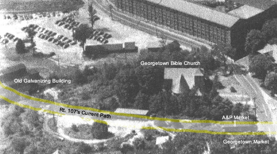
Aerial
Photo from Main St. Area Looking West in about 1946. Shows
what the area in front of the Georgetown Bible Church used
to look like before Rt. 107 came thru...lots of trees, a dirt
path, the A&P Market and the old G&B Galvanizing Building.
The A&P and Galvanizing Building were both removed to
make way for the new roadway in 1953-54.
Old
Mill Road was the main road to Wilton and Norwalk. Early on
it served as the stagecoach road and the first Post Office
in Georgetown which still stands today was located on the
left as you travel toward Wilton past the two long barns that
used Connery's to store their lime and concrete. Old Mill
Road was important because a large majority of the wire mill
was located there. The mill we see today came later, in the
mid-to-late1800's the mill had nine buildings, two wire factories
and a sieve factory off Old Mill Road. There was also a Railroad
Depot across from the Post Office and Doctor L. Seeley's office.
Off of Old Mill Road was the Polish community on Bunker Hill.
Heading
back to North Main Street, if upon entering Georgetown from
Redding you were to take a right toward the Georgetown Bible
Church and the wire mill, you could stay right and head up
Portland Avenue or continue straight on North Main St.
A
map
of Portland Avenue in 1867 (under the "OWN"
in the word Georgetown) shows this road was originally a dirt
road extending only to a G&B building. Portland Avenue from
the information available began expanding with the factory
from 1867 into the turn of the century as more workers came
and required housing. Gilbert & Bennett records show houses
on this street built by the factory from 1870 to 1925.
Continuing
straight would take you on North Main Street over the Norwalk
River and past the factory which in 1867 housed the Saw Mill,
Glue Factory and Sieve Factory. Today this road is closed
due to the factory redevelopment. It used to cross over rail
tracks at the old employee entrance to the factory.
[These
rail tracks branched off from the main rail-line just before
the old Georgetown Train Station, two team tracks split to
the left, one led to the back of Georgetown Station and one
extended further to the road. The main spur track split to
the right, joining again in the factory. In addition to Miller's
Hall which was located behind the old parking lot, two small
sheds also stood, one of them was a coal shed.]
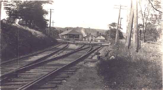
Past
the rail tracks/employees entrance on the left is the Post
Office building built by Gilbert and Bennett in 1906. Up the
hill on the right was the former company's cafeteria, and
two superintendent houses. Before the large mill went up more
houses stood there, in 1867 occupied by G. Albin, C. Albin,
E. Gilbert, Mrs. Berry, B. Bennett (in that order up to the
tracks), D.H. Miller on the right past the tracks and H. St.
John straight ahead at the stop sign.
Church
Street existed and extended to Route 7 and what is now 107.
West Church Street was there as well accessing Route 7 and
housing mill workers. Traveling Church Street in the opposite
direction to 107, imagine a hill to your right that my grandfather
explained was leveled off as Georgetown modernized. The hill,
School Street, was a winter favorite for sledding and it took
steel nerves to master the sharp left-hand turn down Church
St. The original Gilbert and Bennett school sat atop this
hill on the right. The school burnt down in the 1927 or 28.
The school we see today was built in 1915 on New Street. South
Church Street, now a dead end, once extended across the railroad
tracks, followed the river, crossed it and connected with
Old Mill Road at the Redding/Weston line. Smith Street, where
my grandfather grew up, was originally supposed to extend
through what is now Pryor/Hubbard Hall to North Main Street.
This never happened and it remained a dead end street. Before
the Route 107 bridge was built, the road extended to South
Church Street and down to Old Mill Road. (View
Map)
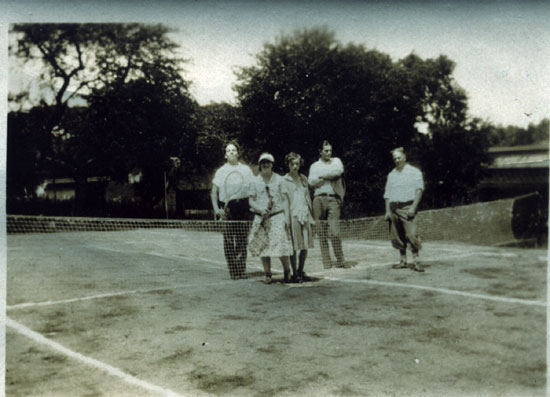
Tennis Court that
used to be about where Pryor-Hubbard Hall is now
Back
to TOP | Back to Redding
Section | Back to Georgetown
Section
|